|
Bad River Wisconsin, Fishing Reports
and Conditions
 The
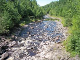
Bad River is a river flowing to Lake Superior in
northern Wisconsin in the United States. It flows for 76
miles (122 km) in Ashland County, draining an area of 1,061
square miles (2,748 km²) in portions of Ashland, Bayfield
and Iron Counties. The
Bad River is a river flowing to Lake Superior in
northern Wisconsin in the United States. It flows for 76
miles (122 km) in Ashland County, draining an area of 1,061
square miles (2,748 km²) in portions of Ashland, Bayfield
and Iron Counties.
The Bad River issues from
the southwestern end of Caroline Lake, a 129 acre shallow
lake on the boundary of Ashland and Iron Counties which
drains an area of acidic peatlands to its east. The Bad
River initially flows southwestwardly before turning
generally to the north for most of its course, along which
it passes through the city of Mellen, Copper Falls State
Park, and the community of Odanah in the Bad River Indian
Reservation. In the vicinity of Mellen, the riverbed is
commonly bedrock and boulder-strewn with numerous whitewater
rapids; the river passes over waterfalls and through a
granite gorge in Copper Falls State Park. In its lower
course in the Bad River Reservation the river's delta along
Lake Superior contributes to a 16,000 acre complex of
wetlands known as sloughs.
The Bad River's largest
tributary is the White River, which it collects near its
mouth. Other principal tributaries include the Potato and
Marengo Rivers in its lower course; the Tyler Forks at
Copper Falls State Park; and the Iron River upstream of
Mellen.
Click on a
Guide's Name below for their report in this area.
 Jeff
Bolander - Greater Minocqua & North Lakeland
(Manitowish Waters, Presque Isle, Winchester and Boulder
Junction) areas.
Jeff's website Jeff
Bolander - Greater Minocqua & North Lakeland
(Manitowish Waters, Presque Isle, Winchester and Boulder
Junction) areas.
Jeff's website |
|
We
are Proud Members of the

Network
This
site and all pages herein have been designed by and are hosted by
the
Internet Specialists at UpNorth
Publishing, a division of BOTEK
CORPORATION
and are the property of BOTEK CORPORATION.
Copyright © 2016-2017 BOTEK CORPORATION All Rights Reserved.


|
Click on one of our
Sponsors Below
|